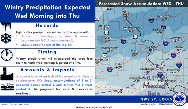
The National Weather Service has issued a Winter Weather Advisory for South Central Illinois from midnight Tuesday night through six Thursday morning.
Mixed precipitation expected. Total snow accumulations of up to one inch and ice accumulations of up to one-tenth of an inch.
Plan on slippery road conditions. The hazardous conditions could impact the evening commute on Wednesday evening.
Here is the more detailed forecast:
Tonight
A slight chance of freezing rain between 1 am and 3 am, then a chance of snow and freezing rain. Cloudy, with a low around 19. North wind 7 to 9 mph. The chance of precipitation is 30%.
Wednesday
A chance of snow and freezing rain, mainly after 7 am. Cloudy, with a high near 25. Northeast wind around 10 mph. The chance of precipitation is 40%.
Wednesday Night
A chance of snow and freezing rain before 11 pm, then a chance of snow. Cloudy, with a low around 19. Northeast wind 10 to 14 mph, with gusts as high as 21 mph. The chance of precipitation is 40%.
Thursday
A chance of snow before 3 pm, then a chance of snow and freezing rain. Cloudy, with a high near 25. Northeast wind around 10 mph, with gusts as high as 20 mph. The chance of precipitation is 30%.
Thursday Night
Mostly cloudy, with a low around 13. North wind 6 to 8 mph.
Friday
Partly sunny, with a high near 22.
Friday Night
Mostly cloudy, with a low around 10.
Saturday
A 20 percent chance of snow after noon. Mostly cloudy and cold, with a high near 18.
Saturday Night
A 20 percent chance of snow before midnight. Mostly cloudy, with a low around -1.
Sunday
Partly sunny and cold, with a high near 11.
Sunday Night
Mostly cloudy, with a low around -3.
Washington’s Birthday
A 20 percent chance of snow. Mostly cloudy and cold, with a high near 15.
Monday Night
A 30 percent chance of snow. Mostly cloudy, with a low around 7.
