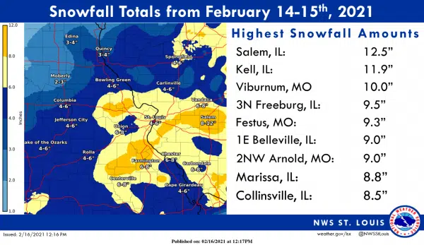
The National Weather Service has put Salem at the top of the list for total snowfall from this week’s snowstorm.
The weather service is placing total snowfall at 12 and a half inches. Kell is second on the list at 11.9 inches. All of Marion County and most of Clinton County were in the heaviest snowfall band of eight to 12 inches. The rest of the region was mostly in the six to eight-inch band.
The weather service is projecting the snowfall from the new snowstorm passing through the area on Wednesday should stay at under an inch of accumulation.
The weather service is also projecting when we move out of the frigid weather pattern starting Sunday we should see temperatures stay above normal for the rest of the month and possibly into early March.
There was another record low set for Wednesday as the temperature fell to three below zero. That broke the old record of one below zero set in 2015. It is the third record low temperature recorded this week at the Salem Water Plant. The high-temperature Tuesday was only 12 degrees.

