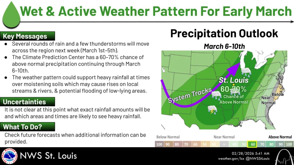
Mixed precipitation is in the forecast for Sunday night and early Monday morning. Rain and snow, possibly mixed with sleet before three am, then rain, possibly mixed with snow, between 3 and 4 am, then rain likely after 4 am. The temperature tonight is expected to stay above freezing, likely hitting a low of 34 before sunrise Monday. A good chance of rain is then forecast from Monday through Saturday, potentially ending the extremely dry weather that has helped fuel brush and grass fires this weekend
Here is the more detailed forecast for the coming week
Monday
A chance of rain, mainly before 9 am, then a chance of showers after noon. Cloudy, with a high near 45. East wind 6 to 10 mph. Chance of precipitation is 40%.
Monday Night
Showers likely, mainly after midnight. Cloudy, with a low around 42. East wind 5 to 8 mph becoming south after midnight. Chance of precipitation is 70%.
Tuesday
Showers likely, mainly before noon. Cloudy, with a high near 64. South wind 8 to 13 mph, with gusts as high as 21 mph. Chance of precipitation is 70%.
Tuesday Night
Showers likely, mainly after midnight. Mostly cloudy, with a low around 56. Chance of precipitation is 70%.
Wednesday
Showers, with thunderstorms also possible after noon. High near 68. Chance of precipitation is 80%.
Wednesday Night
Showers likely and possibly a thunderstorm. Mostly cloudy, with a low around 53. Chance of precipitation is 70%.
Thursday
Showers likely. Mostly cloudy, with a high near 68. Chance of precipitation is 70%.
Thursday Night
A chance of showers and thunderstorms, then showers likely and possibly a thunderstorm after midnight. Mostly cloudy, with a low around 57. Chance of precipitation is 60%.
Friday
A 50 percent chance of showers and thunderstorms. Mostly cloudy, with a high near 72.
Friday Night
Showers and thunderstorms likely. Mostly cloudy, with a low around 54. Chance of precipitation is 60%.
Saturday
Showers likely. Cloudy, with a high near 65. Chance of precipitation is 70%